Local Weather Station (N5ZKK)
Observation Time:
Jun 19 2026 04:45 CDT
Temperature:
79°F
Humidity:
99%
Barometric Pressure:
inHg
Wind Vector:
90° @ 3 mph
Peak Wind Gust:
4 mph
Precipitation (1-Hour):
0.00 in
Precipitation (24-Hour):
0.00 in

GOES Regional Radar Arrays
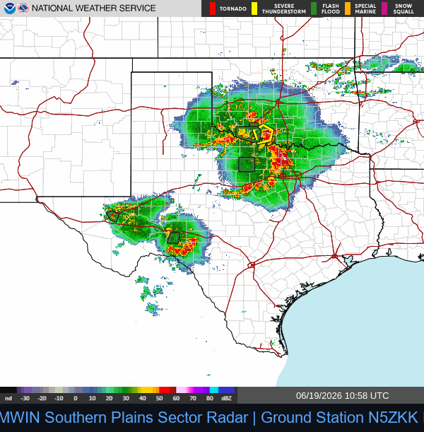
Southern Plains Sector (Texas Local)
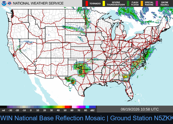
National Radar Mosaic
Active EAS Convective Bulletins (3-Hour Window)
WGUS84 KSJT 190722
FLSSJT
Flood Advisory
National Weather Service San Angelo TX
222 AM CDT Fri Jun 19 2026
TXC447-191030-
/O.NEW.KSJT.FA.Y.0112.260619T0722Z-260619T1030Z/
/00000.N.ER.000000T0000Z.000000T0000Z.000000T0000Z.OO/
Throckmorton TX-
222 AM CDT Fri Jun 19 2026
...FLOOD ADVISORY IN EFFECT UNTIL 530 AM CDT EARLY THIS MORNING...
* WHAT...Small stream flooding caused by excessive rainfall is
expected.
* WHERE...A portion of west central Texas, including the following
county, Throckmorton.
* WHEN...Until 530 AM CDT.
* IMPACTS...Minor flooding in low-lying and poor drainage areas.
* ADDITIONAL DETAILS...
- At 221 AM CDT, Doppler radar indicated heavy rain due to
thunderstorms. This will cause small stream flooding. Up to
1.5 inches of rain have fallen.
- Additional rainfall amounts of 1 to 2 inches are expected
over the area. This additional rain will result in minor
flooding.
- Some locations that will experience flooding include...
Throckmorton, Elbert, Millers Creek Reservoir and Us-183 Near
The Throckmorton-Baylor County Line.
- http://www.weather.gov/safety/flood
PRECAUTIONARY/PREPAREDNESS ACTIONS...
Turn around, don't drown when encountering flooded roads. Most flood
deaths occur in vehicles.
&&
LAT...LON 3340 9941 3340 9938 3340 9937 3340 9926
3340 9895 3337 9895 3330 9895 3325 9895
3322 9895 3314 9895 3316 9924
$$
7
============================================================
WGUS41 KBTV 190942
FLWBTV
BULLETIN - IMMEDIATE BROADCAST REQUESTED
Flood Warning
National Weather Service Burlington VT
542 AM EDT Fri Jun 19 2026
...The National Weather Service in Burlington VT has issued a Flood
Warning for the following rivers in Vermont...
Barton River Near Coventry affecting Orleans County.
PRECAUTIONARY/PREPAREDNESS ACTIONS...
Turn around, don't drown when encountering flooded roads. Most flood
deaths occur in vehicles.
Please report observed flooding to local emergency services or law
enforcement and request they pass this information to the National
Weather Service when you can do so safely.
Additional information is available at www.weather.gov.
The next statement will be issued this afternoon at 400 PM EDT.
&&
VTC019-192000-
/O.NEW.KBTV.FL.W.0005.260619T0942Z-260619T2000Z/
/COVV1.1.ER.260619T0932Z.260619T1100Z.260619T1400Z.NO/
542 AM EDT Fri Jun 19 2026
...FLOOD WARNING IN EFFECT FROM EARLY THIS MORNING TO LATE THIS
AFTERNOON...
* WHAT...Minor flooding is forecast.
* WHERE...Barton River near Coventry.
* WHEN...From early this morning to late this afternoon.
* IMPACTS...At 8.0 feet, Maple Street and River Road between Orleans
and Coventry Station will flood. There will be extensive field and
lowland flooding.
* ADDITIONAL DETAILS...
- At 5:30 AM EDT Friday the stage was 7.9 feet.
- Forecast...The river is expected to rise to a crest of 8.4
feet this morning. It will then fall below flood stage late
this morning.
- Flood stage is 8.0 feet.
- Flood History...No available flood history.
- http://www.weather.gov/safety/flood
&&
LAT...LON 4490 7226 4490 7217 4483 7216 4478 7207
4476 7224
$$
============================================================
WGUS74 KLUB 190935
FFSLUB
Flash Flood Statement
National Weather Service Lubbock TX
435 AM CDT Fri Jun 19 2026
TXC075-101-191-345-191045-
/O.CON.KLUB.FF.W.0036.000000T0000Z-260619T1045Z/
/00000.0.ER.000000T0000Z.000000T0000Z.000000T0000Z.OO/
Childress TX-Cottle TX-Hall TX-Motley TX-
435 AM CDT Fri Jun 19 2026
...FLASH FLOOD WARNING REMAINS IN EFFECT UNTIL 545 AM CDT EARLY THIS
MORNING FOR NORTHERN COTTLE, NORTHEASTERN MOTLEY, SOUTHERN CHILDRESS
AND SOUTHEASTERN HALL COUNTIES...
At 435 AM CDT, radar indicated a line of slow-moving thunderstorms
producing heavy rain across the warned area. Between 1 and 3 inches
of rain have fallen, heaviest in far southeast Hall County.
Additional rainfall amounts up to 1 inch are likely in the warned
area. Flash flooding is ongoing or expected to begin shortly.
HAZARD...Flash flooding caused by thunderstorms.
SOURCE...Radar.
IMPACT...Flash flooding of small creeks and streams, urban areas,
highways, streets and underpasses as well as other poor
drainage and low-lying areas.
Some locations that will experience flash flooding include...
Tell and Northfield.
PRECAUTIONARY/PREPAREDNESS ACTIONS...
Be especially cautious at night when it is harder to recognize the
dangers of flooding.
&&
LAT...LON 3442 10059 3438 10000 3423 10000 3423 10001
3424 10001 3424 10004 3423 10004 3426 10060
FLASH FLOOD...RADAR INDICATED
$$
MCZ
============================================================
WWUS54 KFWD 190942
SVSFWD
Severe Weather Statement
National Weather Service Fort Worth TX
442 AM CDT Fri Jun 19 2026
TXC143-221-190952-
/O.CAN.KFWD.SV.W.0222.000000T0000Z-260619T1015Z/
Erath TX-Hood TX-
442 AM CDT Fri Jun 19 2026
...THE SEVERE THUNDERSTORM WARNING FOR NORTHEASTERN ERATH AND HOOD
COUNTIES IS CANCELLED...
The storms which prompted the warning have moved out of the warned
area. Therefore, the warning has been cancelled.
&&
LAT...LON 3299 9762 3255 9762 3256 9807 3301 9821
TIME...MOT...LOC 0942Z 283DEG 25KT 3298 9794 3273 9789 3257 9801
$$
TXC363-367-191015-
/O.CON.KFWD.SV.W.0222.000000T0000Z-260619T1015Z/
Parker TX-Palo Pinto TX-
442 AM CDT Fri Jun 19 2026
...A SEVERE THUNDERSTORM WARNING REMAINS IN EFFECT UNTIL 515 AM CDT
FOR PARKER AND NORTHEASTERN PALO PINTO COUNTIES...
At 442 AM CDT, severe thunderstorms were located along a line
extending from near Poolville to near Brock to near Lipan, moving
east at 30 mph.
HAZARD...60 mph wind gusts.
SOURCE...Radar indicated.
IMPACT...Expect damage to roofs, siding, and trees.
Locations impacted include...
Weatherford, Mineral Wells, Willow Park, Aledo, Springtown, Brock,
Hudson Oaks, Western Lake, Annetta, Poolville, Cool, Lake Mineral
Wells, Lake Weatherford, Horseshoe Bend, Annetta South, Annetta
North, Millsap, Adell, Advance, and Salesville.
PRECAUTIONARY/PREPAREDNESS ACTIONS...
Continuous cloud to ground lightning is occurring with these storms.
Move indoors immediately.
&&
LAT...LON 3299 9762 3255 9762 3256 9807 3301 9821
TIME...MOT...LOC 0942Z 283DEG 25KT 3298 9794 3273 9789 3257 9801
HAIL THREAT...RADAR INDICATED
MAX HAIL SIZE...<.75 IN
WIND THREAT...RADAR INDICATED
MAX WIND GUST...60 MPH
$$
Shamburger
============================================================
WGUS84 KMRX 190800
FLSMRX
Flood Statement
National Weather Service Morristown TN
400 AM EDT Fri Jun 19 2026
VAC105-167-169-195-720-191000-
/O.CON.KMRX.FA.W.0001.000000T0000Z-260619T1000Z/
/00000.0.ER.000000T0000Z.000000T0000Z.000000T0000Z.OO/
Lee VA-Russell VA-Scott VA-Wise VA-City of Norton VA-
400 AM EDT Fri Jun 19 2026
...FLOOD WARNING REMAINS IN EFFECT UNTIL 6 AM EDT EARLY THIS
MORNING...
* WHAT...Flooding caused by excessive rainfall continues.
* WHERE...A portion of southwest Virginia, including the following
counties and independent city, City of Norton, Lee, Russell, Scott
and Wise.
* WHEN...Until 600 AM EDT.
* IMPACTS...Flooding of rivers, creeks, streams, and other low-lying
and flood-prone locations is imminent or occurring. Streams
continue to rise due to excess runoff from earlier rainfall.
Low-water crossings are inundated with water and may not be
passable.
* ADDITIONAL DETAILS...
- At 357 AM EDT, The public reported slow moving thunderstorms
with very heavy rainfall across the warned area. Between 3
and 5 inches of rain have fallen over the past 12 hours.
- Additional rainfall amounts up to 0.2 inches are possible in
the warned area.
- Some locations that will experience flooding include...
Norton, Wise, Jonesville, Big Stone Gap, Pennington Gap,
Coeburn, Appalachia, St. Paul, Dungannon, St. Charles,
Duffield, Jasper, Dryden, Pattonsville, Fort Blackmore and
Castlewood.
- http://www.weather.gov/safety/flood
PRECAUTIONARY/PREPAREDNESS ACTIONS...
Turn around, don't drown when encountering flooded roads. Most flood
deaths occur in vehicles.
Be especially cautious at night when it is harder to recognize the
dangers of flooding.
In hilly terrain there are hundreds of low water crossings which are
potentially dangerous in heavy rain. Do not attempt to cross flooded
roads. Find an alternate route.
&&
LAT...LON 3685 8307 3687 8291 3692 8286 3699 8241
3696 8236 3698 8231 3690 8228 3664 8290
3661 8326 3672 8325 3674 8314 3678 8313
$$
============================================================
WGUS84 KOUN 190934
FLSOUN
Flood Advisory
National Weather Service Norman OK
434 AM CDT Fri Jun 19 2026
OKC031-033-141-191245-
/O.NEW.KOUN.FA.Y.0150.260619T0934Z-260619T1245Z/
/00000.N.ER.000000T0000Z.000000T0000Z.000000T0000Z.OO/
Comanche OK-Cotton OK-Tillman OK-
434 AM CDT Fri Jun 19 2026
...FLOOD ADVISORY IN EFFECT UNTIL 745 AM CDT THIS MORNING...
* WHAT...Flooding caused by excessive rainfall is expected.
* WHERE...A portion of southwest Oklahoma, including the following
counties, Comanche, Cotton and Tillman.
* WHEN...Until 745 AM CDT.
* IMPACTS...Minor flooding in low-lying and poor drainage areas.
* ADDITIONAL DETAILS...
- At 434 AM CDT, Doppler radar indicated heavy rain due to
thunderstorms. Minor flooding is ongoing or expected to begin
shortly in the advisory area. Between 1 and 2 inches of rain
have fallen.
- Some locations that will experience flooding include...
Frederick, Grandfield, Chattanooga, Davidson, Manitou, Devol,
Faxon, Hollister and Loveland.
- http://www.weather.gov/safety/flood
PRECAUTIONARY/PREPAREDNESS ACTIONS...
Turn around, don't drown when encountering flooded roads. Most flood
deaths occur in vehicles.
Be especially cautious at night when it is harder to recognize the
dangers of flooding.
&&
LAT...LON 3441 9842 3415 9859 3416 9865 3413 9869
3413 9874 3416 9883 3415 9887 3417 9887
3418 9892 3421 9895 3420 9897 3422 9899
3420 9904 3421 9910 3426 9915 3453 9910
3455 9871
$$
Mahale
============================================================
WGUS84 KMOB 190708
FLSMOB
Flood Statement
National Weather Service Mobile AL
208 AM CDT Fri Jun 19 2026
...The Flood Warning is extended for the following rivers in
Alabama...
Murder Creek At Brewton affecting Escambia County.
For the Murder Creek...including Brewton...Minor flooding is
forecast.
PRECAUTIONARY/PREPAREDNESS ACTIONS...
Turn around, don't drown when encountering flooded roads. Most flood
deaths occur in vehicles.
Motorists should not attempt to drive around barricades or drive cars
through flooded areas.
Additional information is available at www.weather.gov/mob. Click on
the Rivers and Lakes menu for forecasts and observations.
The next statement will be issued when updates occur.
&&
ALC053-191915-
/O.EXT.KMOB.FL.W.0033.260619T1737Z-260621T1000Z/
/BWMA1.1.ER.260619T1737Z.260620T0600Z.260621T0400Z.NO/
208 AM CDT Fri Jun 19 2026
...FLOOD WARNING NOW IN EFFECT FROM THIS AFTERNOON TO LATE SATURDAY
NIGHT...
* WHAT...Minor flooding is forecast.
* WHERE...Murder Creek at Brewton.
* WHEN...From this afternoon to late Saturday night.
* IMPACTS...At 24.0 feet, Flooding of Highway 29/Mildred Street
begins.
* ADDITIONAL DETAILS...
- At 1:45 AM CDT Friday the stage was 19.3 feet.
- Forecast...The river is expected to rise above flood stage this
afternoon to a crest of 23.3 feet just after midnight tonight. It
will then fall below flood stage late tomorrow evening.
- Flood stage is 22.0 feet.
- http://www.weather.gov/safety/flood
&&
LAT...LON 3114 8704 3113 8701 3107 8709 3108 8713
$$
10
============================================================
WWUS85 KREV 190910
RFWREV
URGENT - FIRE WEATHER MESSAGE
National Weather Service Reno NV
210 AM PDT Fri Jun 19 2026
CAZ270-278-NVZ458-200300-
/O.CON.KREV.FW.W.0004.260619T1500Z-260620T0600Z/
Surprise Valley California-Eastern Lassen County-
Northern Washoe County-
210 AM PDT Fri Jun 19 2026
...RED FLAG WARNING REMAINS IN EFFECT FROM 8 AM THIS MORNING TO
11 PM PDT THIS EVENING FOR THUNDERSTORMS AND STRONG OUTFLOW WINDS
FOR THE SURPRISE VALLEY, EASTERN LASSEN AND NORTHERN WASHOE
COUNTIES...
* CHANGES...No changes.
* Affected Area...Fire Weather Zone 270 Surprise Valley
California, Fire Weather Zone 278 Eastern Lassen County, Fire
Weather Zone 458 Northern Washoe County.
* Thunderstorms...Isolated dry lightning will be possible this
morning before thunderstorm coverage increases by the afternoon.
* Outflow Winds...Gusty and erratic thunderstorm outflow winds,
even well away from rain cores. Gusts to around 50 mph
possible.
* Impacts...Lightning can create new fire starts and may combine
with strong outflow winds to cause a fire to rapidly grow in
size and intensity before first responders can contain them.
PRECAUTIONARY/PREPAREDNESS ACTIONS...
Avoid outdoor activities that can cause a spark near dry
vegetation, such as yard work, target shooting, or campfires.
Follow local fire restrictions. Check weather.gov/reno for
updates and livingwithfire.info for preparedness tips.
&&
$$
NVZ420-421-200300-
/O.CON.KREV.FW.W.0004.260619T1900Z-260620T0400Z/
Northern Sierra Front including Carson City, Douglas, Storey,
Southern Washoe, Western Lyon, and Far Southern Lassen Counties-
Southern Sierra Front including Alpine, Northern Mono, Southern
Lyon, and Western Mineral Counties-
210 AM PDT Fri Jun 19 2026
...RED FLAG WARNING REMAINS IN EFFECT FROM NOON TODAY TO 9 PM PDT
THIS EVENING FOR THUNDERSTORMS AND STRONG OUTFLOW WINDS FOR THE
SIERRA FRONT...
* CHANGES...No changes.
* Affected Area...Fire Weather Zone 420 Northern Sierra Front
including Carson City, Douglas, Storey, Southern Washoe,
Western Lyon, and Far Southern Lassen Counties, Fire Weather
Zone 421 Southern Sierra Front including Alpine, Northern
Mono, Southern Lyon, and Western Mineral Counties.
* Thunderstorms...Thunderstorm coverage and dry lightning
potential will become more widespread by the afternoon into the
evening.
* Outflow Winds...Gusty and erratic thunderstorm outflow winds,
even well away from rain cores. Gusts to around 50 mph
possible today and Friday afternoon.
* Impacts...Lightning can create new fire starts and may combine
with strong outflow winds to cause a fire to rapidly grow in
size and intensity before first responders can contain them.
PRECAUTIONARY/PREPAREDNESS ACTIONS...
Avoid outdoor activities that can cause a spark near dry
vegetation, such as yard work, target shooting, or campfires.
Follow local fire restrictions. Check weather.gov/reno for
updates and livingwithfire.info for preparedness tips.
&&
$$
NVZ423-429-200300-
/O.CON.KREV.FW.W.0004.260619T1900Z-260620T0600Z/
West Humboldt Basin in Pershing County-
Lahontan Basin including Churchill and Eastern Mineral Counties-
210 AM PDT Fri Jun 19 2026
...RED FLAG WARNING REMAINS IN EFFECT FROM NOON TODAY TO 11 PM
PDT THIS EVENING FOR THUNDERSTORMS AND STRONG OUTFLOW WINDS FOR
THE WEST HUMBOLDT BASIN IN PERSHING COUNTY...
* CHANGES...No Changes.
* Affected Area...Fire Weather Zone 423 West Humboldt Basin in
Pershing County, Fire Weather Zone 429 Lahontan Basin
including Churchill and Eastern Mineral Counties.
* Thunderstorms....A mix of wet and dry thunderstorms by the early
afternoon into the late evening.
* Outflow Winds...Gusty and erratic thunderstorm outflow winds,
even well away from rain cores. Gusts to around 60 mph
possible.
* Impacts...Lightning can create new fire starts and may combine
with strong outflow winds to cause a fire to rapidly grow in
size and intensity before first responders can contain them.
PRECAUTIONARY/PREPAREDNESS ACTIONS...
Avoid outdoor activities that can cause a spark near dry
vegetation, such as yard work, target shooting, or campfires.
Follow local fire restrictions. Check weather.gov/reno for
updates and livingwithfire.info for preparedness tips.
&&
$$
http://weather.gov/reno
============================================================
WGUS84 KMOB 190707
FLSMOB
Flood Statement
National Weather Service Mobile AL
207 AM CDT Fri Jun 19 2026
...The Flood Warning continues for the following rivers in Alabama...
Fish River Near Silverhill affecting Baldwin County.
For the Fish River...including Silverhill...Moderate flooding is
forecast.
PRECAUTIONARY/PREPAREDNESS ACTIONS...
Turn around, don't drown when encountering flooded roads. Most flood
deaths occur in vehicles.
Motorists should not attempt to drive around barricades or drive cars
through flooded areas.
Additional information is available at www.weather.gov/mob. Click on
the Rivers and Lakes menu for forecasts and observations.
The next statement will be issued when updates occur.
&&
ALC003-191915-
/O.EXT.KMOB.FL.W.0034.260619T0735Z-260620T1035Z/
/FSHA1.2.ER.260619T0735Z.260619T1800Z.260620T0435Z.NO/
207 AM CDT Fri Jun 19 2026
...FLOOD WARNING NOW IN EFFECT UNTIL LATE TONIGHT...
* WHAT...Moderate flooding is forecast.
* WHERE...Fish River near Silverhill.
* WHEN...Until late tonight.
* IMPACTS...At 13.0 feet, Houses on River Road begin to flood.
* ADDITIONAL DETAILS...
- At 1:30 AM CDT Friday the stage was 10.7 feet.
- Forecast...The river is expected to rise above flood stage early
this morning to a crest of 13.0 feet this afternoon. It will then
fall below flood stage late this evening.
- Flood stage is 11.0 feet.
- http://www.weather.gov/safety/flood
&&
LAT...LON 3062 8779 3044 8778 3044 8783 3062 8784
$$
10
============================================================
WGUS84 KMOB 190704
FLSMOB
Flood Statement
National Weather Service Mobile AL
204 AM CDT Fri Jun 19 2026
...The Flood Warning continues for the following rivers in Florida...
Big Coldwater Creek Near Milton affecting Santa Rosa and Okaloosa
Counties.
For the Big Coldwater Creek...including Harold, Milton...Minor
flooding is forecast.
PRECAUTIONARY/PREPAREDNESS ACTIONS...
Turn around, don't drown when encountering flooded roads. Most flood
deaths occur in vehicles.
Motorists should not attempt to drive around barricades or drive cars
through flooded areas.
Additional information is available at www.weather.gov/mob. Click on
the Rivers and Lakes menu for forecasts and observations.
The next statement will be issued when updates occur.
&&
FLC091-113-191915-
/O.EXT.KMOB.FL.W.0032.260620T1200Z-260620T1800Z/
/MLNF1.1.ER.260620T1200Z.260620T1200Z.260620T1200Z.NO/
204 AM CDT Fri Jun 19 2026
...FLOOD WARNING NOW IN EFFECT FROM SATURDAY MORNING TO SATURDAY
AFTERNOON...
* WHAT...Minor flooding is forecast.
* WHERE...Big Coldwater Creek near Milton.
* WHEN...From Saturday morning to Saturday afternoon.
* IMPACTS...At 10.0 feet, Flooding of lowlands and some fish camps
will occurs.
* ADDITIONAL DETAILS...
- At 1:00 AM CDT Friday the stage was 6.6 feet.
- Forecast...The river is expected to rise to a crest of 10.0 feet
tomorrow morning.
- Flood stage is 10.0 feet.
- http://www.weather.gov/safety/flood
&&
LAT...LON 3091 8696 3088 8694 3081 8700 3068 8696
3068 8697 3080 8704
$$
10
============================================================
WGUS84 KOUN 190847
FLSOUN
Flood Advisory
National Weather Service Norman OK
347 AM CDT Fri Jun 19 2026
OKC031-033-065-075-141-191200-
/O.NEW.KOUN.FA.Y.0148.260619T0847Z-260619T1200Z/
/00000.N.ER.000000T0000Z.000000T0000Z.000000T0000Z.OO/
Comanche OK-Cotton OK-Jackson OK-Kiowa OK-Tillman OK-
347 AM CDT Fri Jun 19 2026
...FLOOD ADVISORY IN EFFECT UNTIL 7 AM CDT THIS MORNING...
* WHAT...Flooding caused by excessive rainfall is expected.
* WHERE...A portion of southwest Oklahoma, including the following
counties, Comanche, Cotton, Jackson, Kiowa and Tillman.
* WHEN...Until 700 AM CDT.
* IMPACTS...Minor flooding in low-lying and poor drainage areas.
* ADDITIONAL DETAILS...
- At 347 AM CDT, Doppler radar indicated heavy rain due to
thunderstorms. Minor flooding is ongoing or expected to begin
shortly in the advisory area. Up to 1 inch of rain has
fallen.
- Additional rainfall amounts up to 1 inch are expected over
the area. This additional rain will result in minor flooding.
- Some locations that will experience flooding include...
Lawton, Cache, Snyder, Geronimo, Mountain Park, Medicine
Park, Indiahoma, Roosevelt, Faxon, Headrick, Fort Sill, Lake
Lawtonka, Tom Steed Reservoir and Wichita Mountains Wildlife
Refuge.
- http://www.weather.gov/safety/flood
PRECAUTIONARY/PREPAREDNESS ACTIONS...
Turn around, don't drown when encountering flooded roads. Most flood
deaths occur in vehicles.
Be especially cautious at night when it is harder to recognize the
dangers of flooding.
&&
LAT...LON 3490 9909 3482 9883 3478 9869 3467 9825
3440 9826 3438 9852 3452 9870 3453 9909
3461 9926
$$
Mahale
============================================================
WWUS74 KJAN 190910
NPWJAN
URGENT - WEATHER MESSAGE
National Weather Service Jackson MS
410 AM CDT Fri Jun 19 2026
LAZ023>026-MSZ053-054-059>064-072-073-191715-
/O.NEW.KJAN.HT.Y.0002.260619T1600Z-260620T0000Z/
Franklin LA-Catahoula-Tensas-Concordia-Claiborne-Copiah-Jefferson-
Adams-Franklin MS-Lincoln-Lawrence-Jefferson Davis-Marion-Lamar-
Including the cities of Monticello, Bude, Brookhaven, Port
Gibson, Wesson, Winnsboro, Fayette, Ferriday, Bassfield, West
Ferriday, Lumberton, Newellton, Waterproof, Purvis, St. Joseph,
West Hattiesburg, New Hebron, Harrisonburg, Prentiss, Columbia,
Vidalia, Hazlehurst, Natchez, Crystal Springs, Roxie, Jonesville,
and Meadville
410 AM CDT Fri Jun 19 2026
...HEAT ADVISORY IN EFFECT FROM 11 AM THIS MORNING TO 7 PM CDT THIS
EVENING...
* WHAT...Heat index values in excess of 105 degrees expected.
* WHERE...Portions of northeast Louisiana and central, south
central, southeast, and southwest Mississippi.
* WHEN...From 11 AM this morning to 7 PM CDT this evening.
* IMPACTS...Hot temperatures and high humidity may cause heat
illnesses.
* ADDITIONAL DETAILS...These heat indices will occur near or just in
advance of any midday to afternoon showers and thunderstorms.
PRECAUTIONARY/PREPAREDNESS ACTIONS...
Drink plenty of fluids, stay in an air-conditioned room, stay out of
the sun, and check up on relatives and neighbors.
Take extra precautions when outside. Wear lightweight and loose
fitting clothing. Try to limit strenuous activities to early morning
or evening. Take action when you see symptoms of heat exhaustion and
heat stroke.
To reduce risk during outdoor work, the Occupational Safety and
Health Administration recommends scheduling frequent rest breaks in
shaded or air conditioned environments. Anyone overcome by heat
should be moved to a cool and shaded location. Heat stroke is an
emergency! Call 9 1 1.
Monitor the latest forecasts and warnings for updates.
&&
$$
DC
============================================================
WWUS85 KABQ 190712
RFWABQ
URGENT - FIRE WEATHER MESSAGE
National Weather Service Albuquerque NM
112 AM MDT Fri Jun 19 2026
...FIRE WEATHER WATCH IN EFFECT FROM SATURDAY AFTERNOON THROUGH
SATURDAY EVENING DUE TO STRONG WINDS AND LOW RELATIVE HUMIDITY FOR
MOST OF NORTHWESTERN NEW MEXICO...
.Strengthening westerly winds of 15 to 25 mph alongside 6 to 12 hours
of single-digit humidity as well as deep atmospheric mixing will
allow for rapid fire spread or extreme fire behavior across
northwestern New Mexico Saturday afternoon.
NMZ101-105-120-121-192100-
/O.NEW.KABQ.FW.A.0042.260620T1800Z-260621T0100Z/
Northwest Plateau-West Central Mountains-North Central Mountains-
Upper Rio Grande Valley and Lower Chama River Valley-
112 AM MDT Fri Jun 19 2026
...FIRE WEATHER WATCH IN EFFECT FROM SATURDAY AFTERNOON THROUGH
SATURDAY EVENING...
The National Weather Service in Albuquerque NM has issued a Fire
Weather Watch.
* AFFECTED AREA...Northwest Plateau (Zone 101), West Central
Mountains (Zone 105), North Central Mountains (Zone 120), and Upper
Rio Grande Valley and Lower Chama River Valley (Zone 121).
* TIMING...From Saturday afternoon through Saturday evening.
* 20 FOOT WINDS...West winds 15 to 25 mph with gusts up to 35 mph.
* RELATIVE HUMIDITY...Relative humidity between 5 to 10 percent.
* IMPACTS...Any fires that develop will spread rapidly. Outdoor
burning is not recommended.
PRECAUTIONARY/PREPAREDNESS ACTIONS...
Please advise the appropriate officials or fire crews in the field of
this Fire Weather Watch.
&&
$$
24
============================================================
WGUS54 KFWD 190804
FFWFWD
TXC503-191100-
/O.NEW.KFWD.FF.W.0059.260619T0804Z-260619T1100Z/
/00000.U.ER.000000T0000Z.000000T0000Z.000000T0000Z.OO/
BULLETIN - EAS ACTIVATION REQUESTED
Flash Flood Warning
National Weather Service Fort Worth TX
304 AM CDT Fri Jun 19 2026
The National Weather Service in Fort Worth has issued a
* Flash Flood Warning for...
Young County in north central Texas...
* Until 600 AM CDT.
* At 304 AM CDT, Doppler radar indicated thunderstorms producing very
heavy rain across Young County. Radar estimates between 1 and 3
inches of rain have fallen in the past hour. Additional rainfall
amounts of 1 to 3 inches are possible over the next 1 to 2 hours.
Flash flooding is ongoing or expected to begin shortly.
HAZARD...Flash flooding caused by thunderstorms.
SOURCE...Radar indicated.
IMPACT...Flash flooding of small creeks and streams, urban areas,
highways, streets and underpasses as well as other poor
drainage and low-lying areas.
* Some locations that will experience flash flooding include...
Graham, Olney, Lake Graham, Newcastle, Jean, South Bend, Loving,
Eliasville, Murray and Padgett.
This includes the following streams and drainages...
Jim Anderson Creek, Salt Creek, Rock Creek, Cameron Creek, Brushy
Creek, Huffstuttle Creek, Peach Creek, Coal Branch, Plum Creek,
Whiskey Creek, Big Skid Creek, Elm Creek, Fish Creek, Rabbit Creek,
East Kings Creek, Stewart Creek, Bitter Creek, Oak Creek, Little
Salt Creek, Boggy Creek, Clear Fork, West Rock Creek, California
Creek, Cove Creek, Flint Creek, Post Oak Creek, Brazos River,
Farmers Branch, Ratliff Branch, Cribb Station Creek, North Fork
Fish Creek, Dry Creek, Turtle Hole Creek, Willow Pond Creek, Mud
Creek and Tonk Branch.
PRECAUTIONARY/PREPAREDNESS ACTIONS...
Be especially cautious at night when it is harder to recognize the
dangers of flooding.
&&
LAT...LON 3310 9843 3295 9843 3295 9857 3296 9876
3296 9895 3340 9895 3340 9873 3340 9842
3327 9842
FLASH FLOOD...RADAR INDICATED
$$
Shamburger
============================================================
WGUS84 KMOB 190712
FLSMOB
Flood Statement
National Weather Service Mobile AL
212 AM CDT Fri Jun 19 2026
...The Flood Warning continues for the following rivers in Alabama...
Styx River Near Elsanor affecting Baldwin County.
For the Styx River...including Elsanor...Moderate flooding is
forecast.
PRECAUTIONARY/PREPAREDNESS ACTIONS...
Turn around, don't drown when encountering flooded roads. Most flood
deaths occur in vehicles.
Motorists should not attempt to drive around barricades or drive cars
through flooded areas.
Additional information is available at www.weather.gov/mob. Click on
the Rivers and Lakes menu for forecasts and observations.
The next statement will be issued when updates occur.
&&
ALC003-191915-
/O.EXT.KMOB.FL.W.0029.000000T0000Z-260620T0931Z/
/STXA1.2.ER.260619T0906Z.260619T1800Z.260620T0331Z.NO/
212 AM CDT Fri Jun 19 2026
...FLOOD WARNING NOW IN EFFECT UNTIL LATE TONIGHT...
* WHAT...Moderate flooding is forecast.
* WHERE...Styx River near Elsanor.
* WHEN...Until late tonight.
* IMPACTS...At 14.0 feet, Moderate Flood Stage. Water reaches top of
bulkheads on Donovan Circle in the Seminole Landing community.
Upstream, water begins to flood Waterworld and areas near Goat
Cooper Roads.
* ADDITIONAL DETAILS...
- At 1:00 AM CDT Friday the stage was 10.9 feet.
- Forecast...The river is expected to rise above flood stage early
this morning to a crest of 14.0 feet this afternoon. It will then
fall below flood stage late this evening.
- Flood stage is 12.0 feet.
- http://www.weather.gov/safety/flood
&&
LAT...LON 3067 8761 3060 8747 3050 8742 3050 8746
3053 8752 3057 8753 3065 8764
$$
10
============================================================
WGUS84 KMOB 190709
FLSMOB
Flood Statement
National Weather Service Mobile AL
209 AM CDT Fri Jun 19 2026
...The Flood Warning is extended for the following rivers in
Alabama...Florida...
Perdido River Near Barrineau Park affecting Baldwin and Escambia
Counties.
For the Perdido River...including Barrineau Park...Minor flooding is
forecast.
PRECAUTIONARY/PREPAREDNESS ACTIONS...
Turn around, don't drown when encountering flooded roads. Most flood
deaths occur in vehicles.
Motorists should not attempt to drive around barricades or drive cars
through flooded areas.
Additional information is available at www.weather.gov/mob. Click on
the Rivers and Lakes menu for forecasts and observations.
The next statement will be issued when updates occur.
&&
ALC003-FLC033-191915-
/O.EXT.KMOB.FL.W.0028.260619T1028Z-260622T0800Z/
/BRPF1.1.ER.260619T1028Z.260620T0600Z.260622T0200Z.NO/
209 AM CDT Fri Jun 19 2026
...FLOOD WARNING NOW IN EFFECT FROM EARLY THIS MORNING TO LATE SUNDAY
NIGHT...
* WHAT...Minor flooding is forecast.
* WHERE...Perdido River near Barrineau Park.
* WHEN...From early this morning to late Sunday night.
* IMPACTS...At 14.0 feet, Water begins to flood bridge roadway and
Florida side of bridge.
* ADDITIONAL DETAILS...
- At 1:00 AM CDT Friday the stage was 11.0 feet.
- Forecast...The river is expected to rise above flood stage early
this morning to a crest of 15.7 feet just after midnight tonight.
It will then fall below flood stage late Sunday evening.
- Flood stage is 13.0 feet.
- http://www.weather.gov/safety/flood
&&
LAT...LON 3080 8761 3080 8756 3065 8737 3051 8744
3052 8746 3064 8740
$$
10
============================================================
WFUS54 KFWD 190923
TORFWD
TXC363-367-191015-
/O.NEW.KFWD.TO.W.0028.260619T0923Z-260619T1015Z/
BULLETIN - EAS ACTIVATION REQUESTED
Tornado Warning
National Weather Service Fort Worth TX
423 AM CDT Fri Jun 19 2026
The National Weather Service in Fort Worth has issued a
* Tornado Warning for...
Western Parker County in north central Texas...
Northeastern Palo Pinto County in north central Texas...
* Until 515 AM CDT.
* At 423 AM CDT, a severe thunderstorm capable of producing a tornado
was located near Mineral Wells, moving east at 20 mph.
HAZARD...Tornado.
SOURCE...Radar indicated rotation.
IMPACT...Flying debris will be dangerous to those caught without
shelter. Mobile homes will be damaged or destroyed.
Damage to roofs, windows, and vehicles will occur. Tree
damage is likely.
* Locations impacted include...
Weatherford, Mineral Wells, Brock, Cool, Lake Mineral Wells,
Millsap, Adell, Salesville, Brock Junction, Peaster, Bennett,
Authon, and Garner.
This includes Interstate 20 between mile markers 396 and 409.
PRECAUTIONARY/PREPAREDNESS ACTIONS...
Tornadoes are extremely difficult to see and confirm at night. Do not
wait to see or hear the tornado. TAKE COVER NOW!
&&
LAT...LON 3276 9824 3291 9819 3290 9772 3263 9778
TIME...MOT...LOC 0923Z 276DEG 18KT 3281 9814
TORNADO...RADAR INDICATED
MAX HAIL SIZE...<.75 IN
$$
Shamburger
============================================================
WWUS76 KLOX 190704
NPWLOX
URGENT - WEATHER MESSAGE
National Weather Service Los Angeles/Oxnard CA
1204 AM PDT Fri Jun 19 2026
CAZ381-383-200500-
/O.CON.KLOX.WI.Y.0042.260619T2000Z-260620T0500Z/
Western Antelope Valley Foothills-Antelope Valley-
Including the cities of Lake Los Angeles, Elizabeth Lake, Lake
Palmdale, Lancaster, and Palmdale
1204 AM PDT Fri Jun 19 2026
...WIND ADVISORY REMAINS IN EFFECT FROM 1 PM THIS AFTERNOON TO 10 PM
PDT THIS EVENING...
* WHAT...Southwest winds 20 to 30 mph with gusts up to 45 mph
expected.
* WHERE...Antelope Valley and Western Antelope Valley Foothills.
* WHEN...From 1 PM this afternoon to 10 PM PDT this evening.
* IMPACTS...Gusty winds will blow around unsecured objects. Tree
limbs could be blown down.
PRECAUTIONARY/PREPAREDNESS ACTIONS...
Winds this strong can make driving difficult, especially for high
profile vehicles. Use extra caution.
Secure outdoor objects.
&&
$$
CAZ088-372-373-379-380-548-200500-
/O.CON.KLOX.XH.A.0002.260623T1500Z-260626T0400Z/
Santa Clarita Valley-Western San Fernando Valley-Eastern San
Fernando Valley-Western San Gabriel Mountains and Highway
14 Corridor-Eastern San Gabriel Mountains-Los Angeles County San
Gabriel Valley-
Including the cities of Lake Castaic, Warm Springs, Chatsworth,
Woodland Hills, Wrightwood, Acton, Mount Wilson, Mill Creek,
Sunland, East Los Angeles, Pomona, Newhall, Pasadena, San
Gabriel, Northridge, Valencia, Burbank, The Angeles Crest
Highway, Van Nuys, Santa Clarita, Universal City, El Monte, La
Canada Flintridge, Mount Baldy, and Glendale
1204 AM PDT Fri Jun 19 2026
...EXTREME HEAT WATCH REMAINS IN EFFECT FROM TUESDAY MORNING THROUGH
THURSDAY EVENING...
* WHAT...Dangerously hot conditions with temperatures up to 100
possible. Hottest Wednesday and Thursday.
* WHERE...Eastern San Fernando Valley, Eastern San Gabriel
Mountains, Los Angeles County San Gabriel Valley, Santa Clarita
Valley, Western San Fernando Valley, and Western San Gabriel
Mountains and Highway 14 Corridor.
* WHEN...From Tuesday morning through Thursday evening.
* IMPACTS...There is a high risk for dangerous heat illness for
anyone, especially for the very young, the very old, those without
air conditioning, and those active outdoors.
* ADDITIONAL DETAILS...Temperatures are expected to cool slightly
after Thursday but will remain well above normal through next
weekend.
PRECAUTIONARY/PREPAREDNESS ACTIONS...
Drink plenty of fluids, stay in an air-conditioned room, stay out of
the sun, and check up on relatives and neighbors.
&&
$$
CAZ368-200500-
/O.CON.KLOX.XH.A.0002.260623T1500Z-260626T0400Z/
Los Angeles County Inland Coast including Downtown Los Angeles-
Including the cities of Downey, Culver City, Hollywood, Compton,
Norwalk, and Beverly Hills
1204 AM PDT Fri Jun 19 2026
...EXTREME HEAT WATCH REMAINS IN EFFECT FROM TUESDAY MORNING THROUGH
THURSDAY EVENING...
* WHAT...Dangerously hot conditions with temperatures up to 88
possible in Downtown Los Angeles and 85 in Inglewood. Hottest
Wednesday and Thursday.
* WHERE...Los Angeles County Inland Coast including Downtown Los
Angeles.
* WHEN...From Tuesday morning through Thursday evening.
* IMPACTS...There is a high risk for dangerous heat illness for
anyone, especially for the very young, the very old, those without
air conditioning, and those active outdoors.
* ADDITIONAL DETAILS...Temperatures are expected to cool slightly
after Thursday but will remain well above normal through next
weekend.
PRECAUTIONARY/PREPAREDNESS ACTIONS...
Drink plenty of fluids, stay in an air-conditioned room, stay out of
the sun, and check up on relatives and neighbors.
&&
$$
Visit us at http://www.weather.gov/LosAngeles
Rorke
============================================================
WGUS44 KLIX 190908
FLWLIX
BULLETIN - IMMEDIATE BROADCAST REQUESTED
Flood Warning
National Weather Service New Orleans LA
408 AM CDT Fri Jun 19 2026
...Forecast flooding changed from Moderate to Major severity and
increased in duration for the following rivers in Mississippi...
Biloxi River Near Lyman affecting Harrison County.
For the Biloxi River...including Lyman...Major flooding is forecast.
PRECAUTIONARY/PREPAREDNESS ACTIONS...
Turn around, don't drown when encountering flooded roads. Most flood
deaths occur in vehicles.
Motorists should not attempt to drive around barricades or drive cars
through flooded areas.
Additional information is available at www.weather.gov/lix. Click on
the Rivers and Lakes menu for forecasts and observations.
The next statement will be issued when updates are needed.
&&
MSC047-200315-
/O.EXT.KLIX.FL.W.0074.000000T0000Z-260621T1600Z/
/LYMM6.3.ER.260618T1945Z.260619T1200Z.260621T1000Z.NO/
408 AM CDT Fri Jun 19 2026
...FLOOD WARNING NOW IN EFFECT UNTIL SUNDAY MORNING...
* WHAT...Moderate flooding is occurring and major flooding is
forecast.
* WHERE...Biloxi River near Lyman.
* WHEN...Until Sunday morning.
* IMPACTS...At 17.0 feet, There will be major flooding on Loraine
Road near the Lorraine Road bridge. Major roads will be closed
including Lamey Bridge Road and Old Highway 49 at the Little Biloxi
River. Major flooding will occur in Retreat and Riverland Village
Subdivisions.
* ADDITIONAL DETAILS...
- At 3:45 AM CDT Friday the stage was 17.7 feet.
- Bankfull stage is 9.0 feet.
- Recent Activity...The maximum river stage in the 24 hours ending
at 3:45 AM CDT Friday was 17.7 feet.
- Forecast...The river is expected to rise to a crest of 18.5 feet
this morning. It will then fall below flood stage early Sunday
morning.
- Flood stage is 12.0 feet.
- Flood History...This crest compares to a previous crest of 18.5
feet on 09/01/1957.
- http://www.weather.gov/safety/flood
&&
LAT...LON 3048 8901 3048 8909 3055 8912 3055 8905
$$
============================================================
WGUS84 KFWD 190725
FLSFWD
Flood Advisory
National Weather Service Fort Worth TX
225 AM CDT Fri Jun 19 2026
TXC503-191000-
/O.NEW.KFWD.FA.Y.0079.260619T0725Z-260619T1000Z/
/00000.N.ER.000000T0000Z.000000T0000Z.000000T0000Z.OO/
Young TX-
225 AM CDT Fri Jun 19 2026
...FLOOD ADVISORY IN EFFECT UNTIL 5 AM CDT EARLY THIS MORNING...
* WHAT...Flooding caused by excessive rainfall is expected.
* WHERE...Young County in north central Texas...
* WHEN...Until 500 AM CDT.
* IMPACTS...Water over roadways. Some low-water crossings may become
impassable.
* ADDITIONAL DETAILS...
- At 225 AM CDT, Doppler radar indicated heavy rain due to
stationary thunderstorms across Young County. Radar estimates up
to 2 inches of rain have fallen in the past hour. Minor flooding
is ongoing or expected to begin shortly in the advisory area.
- Additional rainfall amounts of 1 to 3 inches are expected over
the area. This additional rain will result in minor flooding.
- Some locations that will experience flooding include...
Graham, Olney, Lake Graham, Newcastle, Jean, Loving and Padgett.
PRECAUTIONARY/PREPAREDNESS ACTIONS...
Be especially cautious at night when it is harder to recognize the
dangers of flooding.
&&
LAT...LON 3295 9843 3314 9895 3315 9895 3340 9895
3340 9873 3340 9842 3327 9842 3315 9842
$$
Shamburger
============================================================
WWUS84 KAMA 190835
AWWAMA
Airport Weather Warning
National Weather Service Amarillo TX
335 AM CDT Fri Jun 19 2026
TXZ012-017-191100-
Potter-Randall-
335 AM CDT Fri Jun 19 2026
...AIRPORT WEATHER WARNING...
The National Weather Service in Amarillo has issued an Airport
Weather Warning for Rick Husband International Airport
and Tradewind Airport for the following hazards...
* WHAT...Cloud to ground lightning within 5 miles of KAMA.
* WHEN...3:45 AM through 6 AM.
* ADDITIONAL DETAILS...Reduced visibility due to heavy rain can be
expected with any thunderstorm.
$$
Texas Hill Country Regional EAS Activations
No regional county activations observed in surrounding sectors.
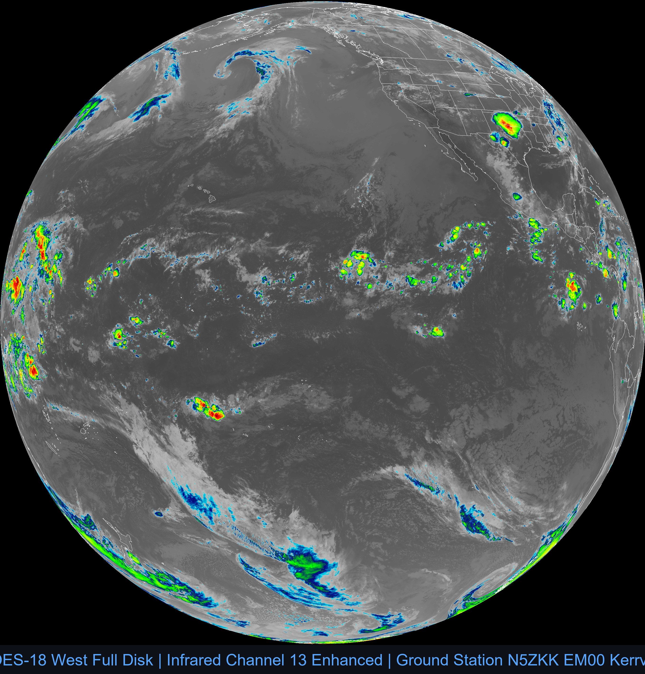
GOES Full Disk Infrared Channels
GOES-19 (East) Full Disk

GOES-18 (West) Full Disk